Endless Possibilities with SLAM and 5G/Cloud Technology Together (Part 2)

We share the basic concept of SLAM with cloud/ 5G network and its example in autonomous mobile robots applications in our previous article. In this second part, we are going to share examples of visual positioning, AR cloud, and autonomous driving applications.
We believe this will help you understand various use cases where SLAM and 5G/Cloud can play a role together.
Use-case examples in visual positioning
We have seen an increasing demand for use cases in the visual positioning of people or machines in an indoor setting together with AMR.
One example is understanding the positions of operators in industrial facilities such as a warehouse or a power plant so that the user can provide a warning to operators when they get close to a hazardous area. The user can also use this information to improve the productivity of operators.
In these applications, the cost of the hardware they wear needs to be very affordable as the solution requires as many units as the number of operators. Generally, more than 100 units are required in a warehouse.
In such a scenario, offloading SLAM processing onto the cloud is the key to minimizing hardware costs. Figure 1 illustrates a suggested architecture to achieve this.
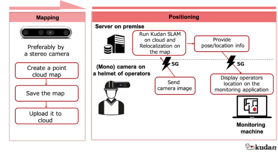
Figure 1: High-level architecture of SLAM on cloud example of operator positioning in a warehouse.
A stereo camera can be used to create a map instead of a mono camera, resulting in more stable performance. However, each positioning/ tracking device mounted can be a mono camera mounted on the helmet to minimize the hardware cost.
This application doesn’t need 5G necessarily, but 5G ensures mission-critical connectivity and low latency for these operators.
Another noteworthy example of visual positioning is forklift position tracking.
Many companies deploy a fleet of manual forklifts and want to understand how efficiently they operate and improve overall productivity. The key to achieving this is recognizing the position of the forklifts.
Since multiple forklifts would be deployed, the hardware costs need to be a bare minimum, and 2D or 3D lidars aren’t an option. We can create a map with one forklift by scanning the area and then using this map to get the positions of forklifts in the area using their stereo camera or even a mono camera, depending on the required accuracy. This architecture is further painted in figure 2.
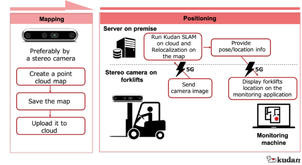
Figure 2: High-level architecture of SLAM on cloud example of forklift position tracking
This scenario doesn’t demand the position of forklifts at every camera image frame (such as 30 fps) but does require something around 1 FPS. So the system could only send 1 pair of images (from the left and right lenses) every second to understand the overview of forklift operations.
As you may have already understood, this application doesn’t need 5G, but 5G would make communication more reliable.
AR Cloud use case example of SLAM and 5G/Cloud
Augmented Reality (AR) Cloud implies an AR application using a map stored on the cloud and also using the position of the device on that map. This is another common usage of SLAM.
However, it is hard to meet the computation and memory requirements for augmented reality applications [1].
For example, a person holds his smartphone and looks around with it. The smartphone understands where it is and which direction the person is facing.
So an AR cloud app can show the direction to a specific location based on this or overlay ads on the actual scenery on the screen. Figure 3 shows the simple architecture of this application.
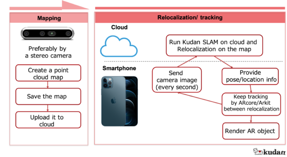
Figure 3: High-level architecture of SLAM on cloud example of AR cloud.
Autonomous driving using SLAM and 5G/Cloud
SLAM on the cloud provides another level of scalability and flexibility to autonomous driving applications.
One of the main challenges of autonomous driving at scale is maintaining up-to-date maps on each of the vehicles. A straightforward solution is to keep a master map on the cloud and let each vehicle consume the necessary part of this map as they drive.
Now the problem gets simpler, as the task is to maintain that single map. So how can we keep this single map up-to-date?
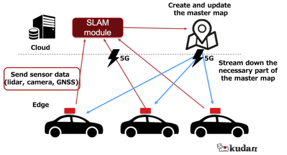
Figure 4: High-level architecture of SLAM on cloud example in autonomous driving.
One approach is using sensor data from each vehicle and updating the single map whenever needed using this data. Thus each vehicle not only consumes the map data but also acts as a mapping agent, as seen in figure 4.
The system could adjust how what portion of the map each vehicle downloads based on the vehicle speed and the network speed. As you already might have guessed, 5G can help download the partial map with low latency and stable connectivity to each vehicle.
Final words
This article showed how cloud and 5G communication technology could help SLAM be widely adopted across multiple use cases.
The examples we showed prove that this crossover of technologies adds more flexibility to how the SLAM can be used. Of course, the use cases we’ve listed here may not be all, and you may have your specific use case requirements for the business problems you have at hand.
Say hi, and we’d be happy to help you transform your business through our SLAM solutions!
References
[1] Jiao, J., Yun, P. and Liu, M. (2017). A Cloud-Based Visual SLAM Framework for Low-Cost Agents. 471–484. [PDF]