Kudan has already been demonstrating outstanding capability in important use cases.

AMR (Outdoor, Indoor-Outdoor mix)
Use Case Description Various types of AMRs which mainly operate at outdoor or indoor-outdoor mix environments such as factory, construction site, office building, shopping mall and hospital, especially with dynamic objects and scenery changes. Overview Visual/3D-Lidar based SLAM enables operating AMR at following environments/usage, which existing GNSS/GPS based outdoor AMR couldn’t handle: GNSS/GPS denied or […]

Industrial/ construction/ mining/ forestry machineries
Use Case Description Autonomous driving and/or teleoperation use cases for various types of industrial machines, where especially can’t depend on GNSS/GPS base localization: Various size of trucks that operate at factory, construction site, port, query etc. Construction/heavy machinery such as excavator, bulldozer, wheel loader, tunnel boring machine etc. Overview In outdoor / outdoor-indoor mixed environments […]

RTLS for machinerys
Use Case Description Real Time Location System (RTLS) or trajectory logging system for various usage such as real time remote monitoring, utilization analysis and optimization. Monitoring targets are various such as forklifts, picking carts, and even workers/staffs. Overview Visual/3D-Lidar based SLAM enables recording location/trajectory without limitation which existing technologies (e.g. beacon, marker, RFID) face: No […]
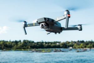
Drones
Use Case Description Various type of drones such as used for surveying, maintenance and delivery, where especially can’t depend on GNSS/GPS base localization. Overview Localization for autonomous flight Kudan SLAM is a critical element of autonomous flight; accurate location, especially when GNSS is denied or unstable. 3D-Mapping Kudan SLAM provides high accurate point cloud data […]
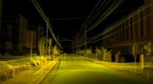
3D Mapping Digital Twin
Use Case Description Generation of point cloud data by using 3D-LiDAR, and used for various use cases: Work progress management at construction site Management and maintenance of infrastructure, facility, and other assets (e.g. municipality, utility, railway, public road) Layout and utilization simulation at factory Disaster countermeasure simulation for city Forest survey and more Overview Previous […]
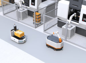
AMR (Indoor)
Use Case Description Various types of AMRs which mainly operate at indoor environments such as factory, office building, shopping mall and hospital, especially with dynamic objects and scenery changes. Overview Visual/3D-Lidar based SLAM enables operating AMR at following environments/usage, which existing 2D-Lidar based indoor AMR couldn’t handle: High robustness even in environment with dynamic objects […]

AD / ADAS (Autonomous Driving / Advanced Driver-Assistance System)
Use Case Description Autonomous driving (AD) system for various types of vehicles including passenger vehicles, and Advanced Driver-Assistance System (ADAS) such as Auto Valet Parking (AVP) system and dynamic object detection, including areas where GNSS/GPS is denied or unstable. Overview Autonomous Driving (AD) Kudan SLAM is a critical element of autonomous driving; accurate location, supported […]